![]()
Mapworks is a studio based in The Netherlands specialized in open source GIS, remote sensing, and web mapping.
Services
- Interactive mapping and visualization of geospatial data.
- Data analysis and processing of large environmental datasets.
- Consulting and technical services.
For questions, collaboration, or more information please e-mail info@mapworks.nl.
Portfolio
Below is a selection of recent projects and other activities.
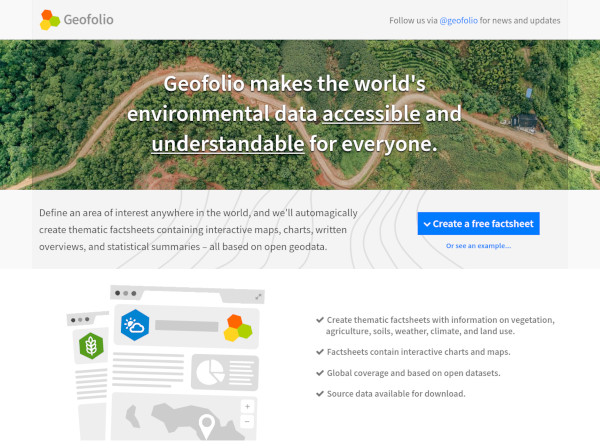
Geofolio is a small project with a big vision: to make the world's environmental data accessible and understandable for everyone (2019-present).
Environmental data is notoriously difficult to use for non-experts and professionals in argiculture, nature conservation, or sustainability. It gets archived away in confusing data portals and is unusable for those who arguably need it most.
Geofolio simplifies this by reducing the process to only one step: Select an area on Earth that you're interested in. It will then automatically generate a factsheet for you about that area containing basic information about land cover, elevation, hydrology, soils, and crops.
All data is downloadable in accessible GIS formats for further exploration.
Using Open Geodata to Detect Deforestation and Land Use Change Hotspots (2021).
Together with the SourceUp platform at IDH we developed a methodology to detect deforestation and land use change hotspots based on data by Global Forest Watch, Mapbiomas, Copernicus Land Cover Products, and Planet/NICFI satellite imagery.
An offline PDF report is generated with maps of the hotspots. For each hotspot, sattelite imagery from Planet is collected from just before and after the change for verification and validation purposes.

Snapspace is a simple collaboration space for groups (2018-2020).
Snapspace was a departure from applications built on geodata, and is a simple ephemeral online collaboration space for groups, where you could easily invite other members across different organizations and share documents, images, messages, and events.
Snapspace unfortunately did not gain enough traction to support it any longer and has stopped accepting new signups since 2020.

PostGIS-Baselayers is an open source tool for easily importing geodatasets into a PostGIS database.
PostGIS-Baselayers is a web application that functions as a management frontend for a spatial PostGIS database. It comes with predefined scripts that will import a selection of open datasets into your PostGIS database at the click of a button.

Other expertise:
- Consulting and software development for various remote sensing companies in The Netherlands to develop web mapping applications, digital cartography, geodata dashboards, decision support systems, or processing pipelines for satellite data.
- A selection of online technical articles such a very popular guide to GeoTIFF compression and optmization, georeferencing and digitizing old maps, working with geospatial data on Amazon Web Services, and others.
- Experience with drought monitoring and designing parametric insurance products based on satellite data.
- Development of web-based uncertainty visualizations and an integrated web-based environmental modelling environment.